Stereophotogrammetry

Stereophotogrammetry: A Depth-Centric Approach to Imaging

Stereophotogrammetry is a precise 3D imaging technique that uses two or more photographs taken from different angles. By analyzing the parallax between images, it accurately reconstructs the shape and dimensions of objects, essential for applications in architecture, forensics, and biomechanics.

Stereophotogrammetry

Overview

Stereophotogrammetry, a technological marvel rooted in the fusion of photography and surveying, has become an indispensable tool across various industries. This advanced technique involves the creation of precise 3D models from two or more overlapping photographs. With applications ranging from cartography and archaeology to engineering and healthcare, stereophotogrammetry has evolved into a versatile and powerful method for capturing and analyzing spatial data. In this article by Academic Block, we will explore the intricacies of stereophotogrammetry, exploring its principles, methodologies, applications, and the evolving landscape of this captivating technology.

Historical Overview

To truly appreciate the significance of stereophotogrammetry, it is essential to trace its roots back to the early days of photography and surveying. The concept of deriving three-dimensional information from two-dimensional images can be traced back to the mid-19th century when the pioneers of photography, such as Louis Daguerre and William Henry Fox Talbot, were experimenting with the medium. The advent of aerial photography during World War I marked a turning point, paving the way for the development of stereophotogrammetry as a systematic and reliable methodology.

Principles of Stereophotogrammetry

Parallax and Depth Perception

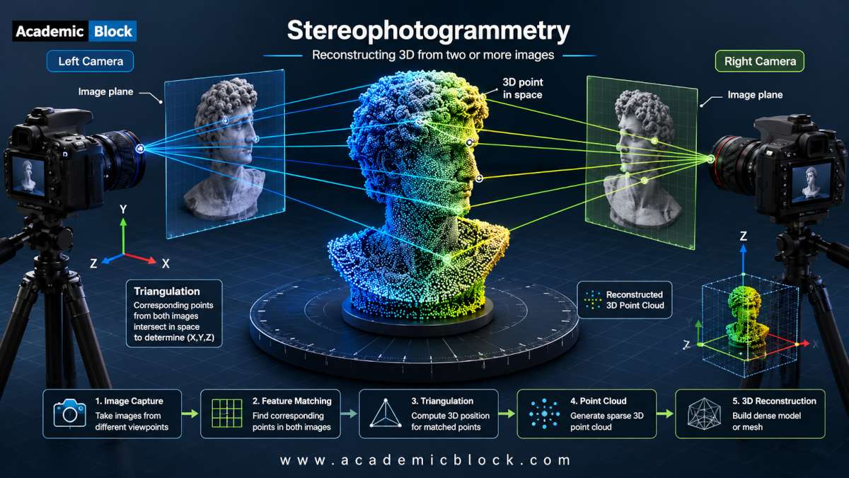
At the core of stereophotogrammetry lies the principle of parallax, a phenomenon where an object appears to shift its position when viewed from different angles. In the context of stereophotogrammetry, this parallax effect is harnessed by capturing images of the same scene from multiple perspectives. The resulting pair of overlapping images allows for the extraction of depth information, enabling the reconstruction of a three-dimensional model.

Epipolar Geometry

The mathematical foundation of stereophotogrammetry is built upon the concept of epipolar geometry. This refers to the geometric relationship between corresponding points in two images captured by different cameras. By establishing this relationship, the position and orientation of the cameras can be calculated, facilitating the reconstruction of the 3D scene with high precision.

Father of Stereophotogrammetry

The term “father of Stereophotogrammetry” is often attributed to Eduard Doležal, an Austrian engineer who made significant contributions to the development and application of stereophotogrammetry in the early 20th century. Doležal’s work laid the foundation for the systematic use of aerial photographs in surveying and mapping. In the 1920s, Eduard Doležal conducted extensive research on stereophotogrammetry, particularly focusing on the mathematical and practical aspects of using overlapping aerial photographs to create accurate 3D models of the Earth’s surface. His pioneering efforts contributed to the establishment of stereophotogrammetry as a scientific and practical methodology.

It is also important to note that this field is the result of collaborative efforts by multiple researchers and practitioners over the years. The contributions of individuals like Carl Pulfrich, Albrecht Meydenbauer, and others has also played crucial roles in advancing the principles and applications of stereophotogrammetry.

Stereophotogrammetry Methodologies

Aerial Stereophotogrammetry

One of the earliest and most prominent applications of stereophotogrammetry is in the field of aerial surveying. Aerial stereophotogrammetry involves capturing overlapping images of the Earth’s surface from an elevated position, typically using aircraft or drones. This methodology is employed for various purposes, including topographic mapping, land surveying, and environmental monitoring. The use of sophisticated airborne sensors and cameras has significantly enhanced the accuracy and efficiency of aerial stereophotogrammetry.

Close-Range Stereophotogrammetry

In scenarios where the subject of interest is in close proximity to the cameras, close-range stereophotogrammetry comes into play. This methodology is extensively utilized in fields such as archaeology, architecture, and industrial measurement. The use of calibrated cameras and precise control over the imaging geometry allows for the creation of detailed and accurate 3D models, even in confined spaces.

Satellite Stereophotogrammetry

With the advancement of satellite technology, stereophotogrammetry has expanded its reach beyond the Earth’s atmosphere. Satellite-based stereophotogrammetry involves capturing stereo pairs of images from orbiting satellites equipped with advanced sensors. This approach is instrumental in applications such as terrain mapping, disaster monitoring, and urban planning on a global scale.

Mathematical equations behind the Stereophotogrammetry

The mathematical equations behind stereophotogrammetry involve principles of geometry, trigonometry, and linear algebra. The fundamental concepts are based on the geometry of the imaging system, the relationship between corresponding points in stereo images, and the triangulation process to determine the three-dimensional coordinates of objects. Here, I’ll provide an overview of some key equations and concepts involved in stereophotogrammetry:

  1. Epipolar Geometry: The relationship between corresponding points in two stereo images is described by epipolar geometry. The essential matrix (E) represents this relationship. If x and x′ are corresponding points in two images, the epipolar constraint is given by:

    x′T E x = 0;

    Here, x and x′ are homogeneous coordinates of points in the left and right images, and E is the essential matrix.

  2. Projection Matrix: The projection matrix (P) relates the 3D world coordinates (X) to the image coordinates (x) in a perspective camera model:

    x = P X;

    Where P is a 3×4 matrix composed of the camera’s intrinsic and extrinsic parameters.

  3. Fundamental Matrix: The fundamental matrix (F) is related to the essential matrix and represents the geometric relationship between corresponding points in stereo images:

    x′T F x = 0;

  4. Triangulation: The process of determining the 3D coordinates (X) of a point using its corresponding points in two images involves triangulation. Given two projection matrices P1 and P2, and the image coordinates x1 and x2, the triangulation equation is:

    X = Triangulate(P1, P2, x1, x2);

    The triangulation method depends on linear algebra and homogeneous coordinates.

  5. Collinearity Condition: The collinearity condition is a fundamental concept in photogrammetry, stating that the object point, the camera center, and the image point are collinear. This condition is mathematically expressed as:

    X × (PX) = 0;

    Here, x denotes the cross product.

  6. Intersection Equation: For aerial photogrammetry, the intersection equation relates the object space coordinates (X), the camera coordinates (Xc), and the image coordinates (x). It is given by:

    X = Xc + λP (Xc);

    Here, λ is a scaling factor.

  7. Bouguer’s Equation: In close-range photogrammetry, Bouguer’s equation is used for the collinearity condition:

    aX + bY + cZ + d = 0;

    Here, a, b, c, and d are coefficients, and X, Y, and Z are the object coordinates.

These equations provide the mathematical foundation for the principles of stereophotogrammetry. Depending on the specific application, additional parameters and variations of these equations may be used to model the imaging system accurately and derive precise 3D information from stereo image pairs.

Applications of Stereophotogrammetry

Cartography and Geographic Information Systems (GIS)

Stereophotogrammetry has revolutionized the field of cartography and GIS by enabling the creation of highly accurate and detailed maps. The three-dimensional information obtained through stereophotogrammetry enhances the precision of elevation models, land cover classification, and urban planning. GIS applications, in particular, benefit from the integration of stereophotogrammetric data for spatial analysis and decision-making.

Archaeology and Cultural Heritage

In archaeology, stereophotogrammetry plays a crucial role in documenting and preserving cultural heritage sites. The ability to create detailed 3D models of archaeological remains facilitates virtual reconstructions, aiding researchers in studying historical structures and artifacts without the need for physical intervention. This application has proven invaluable in the preservation and conservation of cultural heritage.

Engineering and Construction

The engineering and construction industries leverage stereophotogrammetry for various purposes, including site planning, monitoring construction progress, and assessing structural integrity. By creating accurate 3D models of construction sites, engineers can optimize project workflows, detect potential issues early on, and streamline decision-making processes.

Medical Imaging and Healthcare

In the realm of medical imaging, stereophotogrammetry contributes to advancements in patient care and treatment planning. Applications range from facial reconstruction in plastic surgery to orthopedic assessments for personalized implant design. The non-invasive nature of stereophotogrammetry makes it a valuable tool in the medical field, providing detailed anatomical information without the need for invasive procedures.

Environmental Monitoring

Stereophotogrammetry is instrumental in environmental monitoring and management. It aids in assessing changes in terrain, monitoring deforestation, and studying natural disasters. The ability to generate accurate 3D models of landscapes over time facilitates the analysis of environmental changes and supports sustainable resource management.

Challenges and Advances

While stereophotogrammetry has made significant strides, it is not without its challenges. Issues such as occlusions, image distortions, and the need for precise camera calibration can impact the accuracy of reconstructed 3D models. However, ongoing research and technological advancements continue to address these challenges.

Computer Vision and Machine Learning

The integration of computer vision and machine learning techniques has played a pivotal role in overcoming challenges associated with stereophotogrammetry. Automated algorithms can now identify and match corresponding points in images, reducing the manual effort required for data processing. This has not only accelerated the stereophotogrammetric workflow but has also improved the accuracy of the generated 3D models.

LiDAR Integration

The fusion of stereophotogrammetry with LiDAR (Light Detection and Ranging) technology has become a game-changer in capturing detailed 3D information. LiDAR, which uses laser pulses to measure distances, complements stereophotogrammetry by providing accurate elevation data. The combined use of these technologies enhances the overall precision and reliability of 3D reconstructions, especially in complex and challenging environments.

Future Prospects and Emerging Trends

As technology continues to advance, the future of stereophotogrammetry holds exciting possibilities. The integration of artificial intelligence, improved sensor technologies, and the expansion of unmanned aerial vehicles (UAVs) are poised to further enhance the capabilities of stereophotogrammetry. Real-time data processing, increased automation, and the development of more compact and efficient imaging systems are among the trends that will shape the evolution of this technology.

Augmented Reality and Virtual Reality

The marriage of stereophotogrammetry with augmented reality (AR) and virtual reality (VR) is an emerging frontier with immense potential. The ability to create immersive 3D environments using stereophotogrammetric data opens up new avenues for applications in gaming, simulation, and training. This convergence is likely to redefine user experiences and push the boundaries of what is possible in the realm of spatial visualization.

Precision Agriculture

In the agricultural sector, stereophotogrammetry is increasingly being employed for precision agriculture. By generating detailed 3D models of farmland, farmers can gain insights into crop health, assess soil conditions, and optimize resource allocation. This application has the potential to revolutionize farming practices, contributing to sustainable and efficient agricultural processes.

Final Words

Stereophotogrammetry stands as a testament to the synergy between photography, surveying, and advanced technology. From its humble beginnings in the 19th century to its current ubiquity across diverse industries, this method has continually evolved and adapted to the changing technological landscape. Through this article by Academic Block, as we look to the future, the fusion of stereophotogrammetry with cutting-edge technologies promises to unlock new possibilities, revolutionizing how we capture, analyze, and interact with spatial data. The journey of stereophotogrammetry, marked by innovation and interdisciplinary collaboration, continues to shape the way we perceive and understand the three-dimensional world around us. Please provide your comments below, it will help us in improving this article. Thanks for reading!

This Article will answer your questions like:

+ What is Stereophotogrammetry and how does it work? >

Stereophotogrammetry is a technique that uses stereo images captured from multiple viewpoints to create 3D models of objects or environments. By analyzing the differences in perspective between these images, stereophotogrammetry calculates the 3D coordinates of points on the object's surface through triangulation, reconstructing its shape and structure in digital form.

+ How are stereo images used to create 3D models in Stereophotogrammetry? >

Stereo images are pairs of photographs taken from slightly different viewpoints, mimicking human binocular vision. In stereophotogrammetry, these images are processed to identify corresponding points (features) in both images. By measuring the displacement of these features between images and knowing the camera parameters and geometry, the software calculates the 3D coordinates of each point using triangulation. This process generates a dense point cloud, which is then used to create a detailed 3D model of the object or scene.

+ What are the key principles behind stereoscopic imaging and triangulation? >

Stereoscopic imaging relies on capturing two slightly offset images, mimicking human binocular vision, to perceive depth and create 3D perception. Triangulation in stereophotogrammetry involves measuring the relative positions of corresponding points in these stereo images and using geometric principles to calculate their precise 3D coordinates. This method leverages known camera parameters, such as focal length and sensor size, along with the angular differences between the viewpoints to accurately reconstruct the spatial coordinates of points on the object's surface.

+ How does Stereophotogrammetry compare to other 3D scanning methods like laser scanning? >

Stereophotogrammetry differs from laser scanning by using optical images and triangulation to reconstruct 3D models, whereas laser scanning employs laser beams to measure distances to points on the surface, creating a point cloud. Stereophotogrammetry is advantageous for capturing detailed surface textures and colors with cameras, while laser scanning excels in accuracy and speed for capturing precise geometric measurements. Each method has specific applications: stereophotogrammetry is ideal for capturing complex shapes and environments, while laser scanning is preferred for engineering, architecture, and industrial metrology requiring high precision.

+ What types of applications benefit from Stereophotogrammetry? >

Stereophotogrammetry finds applications in fields such as archaeology, virtual reality, biomechanics, and anthropometry. It is used for creating accurate 3D models of archaeological sites and artifacts, immersive VR environments, precise measurements of human body dimensions for garment design and ergonomics, and detailed analysis of movement and posture in biomechanical studies.

+ How is accuracy ensured in Stereophotogrammetry measurements? >

Accuracy in Stereophotogrammetry relies on precise camera calibration, ensuring known parameters such as focal length, distortion, and position relative to the scene. Calibration targets and algorithms correct for lens distortions and optimize image processing for accurate feature matching and triangulation. Environmental factors like lighting conditions and image quality also affect accuracy, requiring controlled settings and advanced processing techniques to minimize errors and enhance measurement reliability.

+ What role do cameras and calibration play in Stereophotogrammetry systems? >

Cameras in Stereophotogrammetry systems capture stereo images that are essential for generating 3D models. Calibration involves precisely determining camera parameters such as focal length, lens distortion, and relative positioning. Calibration targets with known dimensions are used to calibrate cameras, ensuring accurate measurement of feature locations and distances. This calibration data is crucial for accurate triangulation and reconstruction of 3D models from stereo image pairs.

+ What are the advantages of using Stereophotogrammetry for biomechanics and anthropometry? >

Stereophotogrammetry offers advantages in biomechanics and anthropometry by providing non-invasive and precise 3D measurements of human body movement, posture, and anatomical dimensions. It enables accurate analysis of joint kinematics, gait analysis, and ergonomic evaluations without the need for invasive markers or instruments. In anthropometry, Stereophotogrammetry facilitates detailed measurements of body proportions and changes, essential for custom clothing design, sports biomechanics, and medical diagnostics.

+ How does lighting and environment affect Stereophotogrammetry results? >

Lighting and environmental conditions significantly impact Stereophotogrammetry results. Uniform lighting minimizes shadows and enhances image quality, aiding feature detection and matching in stereo pairs. Controlled environments reduce variability in image brightness and background clutter, improving accuracy and reliability of 3D reconstructions. Reflections and specular highlights can distort measurements, requiring careful setup and processing techniques to mitigate these effects. Outdoor applications may necessitate adaptive algorithms to handle changing light conditions and environmental challenges, ensuring robust performance in diverse settings.

+ What are the limitations and challenges of Stereophotogrammetry technology? >

Limitations of Stereophotogrammetry include the need for precise calibration and controlled environments to achieve high accuracy. Complex scenes with occlusions or reflective surfaces can hinder feature matching and disrupt triangulation, affecting model quality. Processing large datasets from multiple stereo pairs requires significant computational resources and can be time-consuming. Furthermore, achieving sub-millimeter accuracy in dynamic environments or with moving subjects remains challenging, requiring advanced algorithms and hardware solutions.

+ How does Stereophotogrammetry contribute to fields like archaeology and virtual reality? >

In archaeology, Stereophotogrammetry facilitates the documentation and preservation of archaeological sites and artifacts in 3D, enabling detailed analysis and virtual reconstructions. It aids in site mapping, artifact cataloging, and studying spatial relationships among artifacts and features. In virtual reality (VR), Stereophotogrammetry generates realistic 3D models of environments and objects for immersive experiences. It supports VR applications in architecture, cultural heritage, education, and entertainment, enhancing user interaction and spatial understanding.

+ How are data acquisition and processing handled in Stereophotogrammetry? >

Data acquisition in Stereophotogrammetry involves capturing stereo image pairs from multiple viewpoints using calibrated cameras. These images undergo feature detection, matching, and triangulation to reconstruct 3D point clouds or mesh models. Processing includes correcting lens distortions, refining feature positions, and merging data from different viewpoints to create a coherent 3D representation. Advanced algorithms optimize computational efficiency and accuracy, handling large datasets and complex scenes for various applications.

+ What recent advancements have been made in Stereophotogrammetry techniques? >

Recent advancements in Stereophotogrammetry include enhanced algorithms for real-time processing, improving speed and accuracy in 3D reconstruction. Machine learning techniques are increasingly integrated for automated feature detection and robust matching, reducing manual intervention and optimizing workflow efficiency. Improved camera technology with higher resolution and dynamic range enhances image quality and detail capture. Integration with AI enables semantic understanding and context-aware reconstruction, refining models for specific applications such as autonomous navigation and precision measurement in robotics and industrial settings.

List the hardware and software required for Stereophotogrammetry

Hardware:

  1. Cameras: High-resolution digital cameras with precise lens calibration are essential for capturing stereo pairs of images. Professional-grade cameras with manual settings and interchangeable lenses are often preferred.
  2. Aircraft or Drones (for Aerial Stereophotogrammetry): Unmanned aerial vehicles (UAVs) or traditional aircraft equipped with cameras for aerial surveys. Drones are increasingly popular due to their versatility, cost-effectiveness, and ease of deployment.
  3. Ground Control Points (GCPs): Physical markers on the ground with known coordinates. GCPs are used to georeference and scale the stereophotogrammetric models accurately.
  4. Global Navigation Satellite System (GNSS) Receivers: High-precision GNSS receivers for accurate positioning and georeferencing. These devices are used to collect ground control and camera station coordinates.
  5. Inertial Measurement Units (IMUs): IMUs provide information about the orientation and movement of the camera or platform. This data is crucial for correcting distortions caused by motion during image capture.
  6. LiDAR Systems (Optional): Light Detection and Ranging (LiDAR) sensors can complement stereophotogrammetry by providing accurate elevation data, especially in areas with complex terrain.

Softwares:

  1. Photogrammetry Softwares:
    • Agisoft Metashape: Widely used photogrammetry software for processing aerial and close-range stereo images, generating dense point clouds, and creating 3D models.
    • Pix4D: A comprehensive photogrammetric software suite suitable for various applications, including surveying, agriculture, and construction.
  2. Computer-Aided Design (CAD) Software (Optional): CAD softwares like AutoCAD, Rhino, and Blender are often used for refining and editing 3D models created through stereophotogrammetry.
  3. Geographic Information System (GIS) Software: GIS softwares like ArcGIS and QGIS are essential for integrating and analyzing stereophotogrammetric data within a geographic context.
  4. Image Processing Software: Image processing softwares like Adobe Photoshop, GIMP are used for pre-processing stereo pairs, adjusting colors, and enhancing image quality.
  5. Camera Calibration Software: Softwares like OpenCV, Matlab for calibrating cameras, estimating intrinsic and extrinsic parameters, and correcting lens distortions.
  6. Point Cloud Processing Software: CloudCompare, LASTools and other tools for managing and analyzing dense point clouds generated from stereophotogrammetric data.
  7. GIS Database (Optional): Tools like PostgreSQL with PostGIS Extension for managing and storing geospatial data efficiently.
  8. Visualization Software: Softwares like MeshLab, Unity, and Blender for visualizing and interacting with 3D models created through stereophotogrammetry.
  9. Statistical Software (Optional): Statistical analysis tools like R, Python (with NumPy, SciPy) can be used for quantitative assessments of stereophotogrammetric data.
  10. Training and Analysis Software (Optional): Specialized softwares like ENVI, ERDAS IMAGINE for remote sensing, spectral analysis, and advanced image processing.

Facts on Stereophotogrammetry

Historical Roots: Stereophotogrammetry traces its roots back to the mid-19th century, evolving from early experiments in photography by pioneers such as Louis Daguerre and William Henry Fox Talbot.

Aerial Surveying Revolution: The use of stereophotogrammetry in aerial surveying experienced a significant boost during World War I when military forces utilized aerial photography for mapping and reconnaissance.

Parallax Principle: At the core of stereophotogrammetry is the principle of parallax, where the apparent displacement of objects in two images taken from different perspectives allows for the calculation of depth information.

Epipolar Geometry: Epipolar geometry is a fundamental concept in stereophotogrammetry, describing the geometric relationship between corresponding points in two images captured by different cameras. The essential and fundamental matrices are key components in this geometry.

Camera Calibration: Precise calibration of cameras is crucial in stereophotogrammetry to accurately determine the intrinsic and extrinsic parameters, including focal length, principal point, and lens distortion.

Aerial Stereophotogrammetry: Aerial stereophotogrammetry involves capturing overlapping images of the Earth’s surface from an elevated position, typically using aircraft or drones. It has widespread applications in cartography, land surveying, and environmental monitoring.

Close-Range Stereophotogrammetry: In close-range stereophotogrammetry, the subject of interest is in close proximity to the cameras. This method is used in fields such as archaeology, architecture, and industrial measurement, offering detailed 3D modeling capabilities.

LiDAR Integration: The integration of stereophotogrammetry with LiDAR technology enhances the accuracy of 3D reconstructions, especially in complex terrains. LiDAR provides precise elevation data, complementing the visual information captured by stereophotogrammetry.

GIS and Mapping Applications: Stereophotogrammetry plays a pivotal role in geographic information systems (GIS) and mapping applications. It contributes to the creation of accurate and detailed maps, aiding in urban planning, environmental monitoring, and disaster management.

Medical and Forensic Applications: Stereophotogrammetry is employed in the medical field for applications such as facial reconstruction in plastic surgery and orthopedic assessments. In forensic science, it assists in crime scene documentation and analysis.

Automated Algorithms and Machine Learning: The integration of automated algorithms and machine learning techniques in stereophotogrammetry accelerates the identification and matching of corresponding points in images, reducing the manual effort required for data processing.

Collaboration with Computer Vision: Stereophotogrammetry often collaborates with computer vision techniques to enhance the accuracy and efficiency of 3D reconstructions. This interdisciplinary approach has led to advancements in automated feature extraction and image matching.

Emerging Technologies: The convergence of stereophotogrammetry with emerging technologies, such as augmented reality (AR) and virtual reality (VR), opens up new possibilities for immersive visualization and interactive experiences.

Precision Agriculture: In agriculture, stereophotogrammetry is increasingly applied for precision farming. It allows farmers to assess crop health, optimize resource allocation, and make informed decisions for sustainable agricultural practices.

Open-Source Software: Open-source stereophotogrammetry software, such as OpenSfM and MicMac, provides accessible tools for researchers, professionals, and enthusiasts to engage in 3D reconstruction projects without proprietary constraints.

Academic References on Stereophotogrammetry

Books:

  1. Kraus, K., & Pfeifer, N. (1998). Determination of terrain models in wooded areas with airborne laser scanner data. ISPRS Journal of Photogrammetry and Remote Sensing, 53(4), 193-203.
  2. Mikhail, E. M., Bethel, J. S., & McGlone, J. C. (2001). Introduction to Modern Photogrammetry. John Wiley & Sons.
  3. McGlone, J. C. (2005). Close Range Photogrammetry and 3D Imaging. Whittles Publishing.
  4. Luhmann, T., Robson, S., Kyle, S., & Boehm, J. (2016). Close Range Photogrammetry: Principles, Techniques, and Applications. Walter de Gruyter.
  5. Fraser, C. S. (2011). Digital Camera and Image Compression Systems. CRC Press.
  1. Bethel, J. S., McGlone, J. C., & Mikhail, E. M. (2009). Introduction to Modern Photogrammetry (5th ed.). John Wiley & Sons.

Journals:

  1. Remondino, F., & El-Hakim, S. (2006). Image-based 3D modeling: a review. Photogrammetric Record, 21(115), 269-291.
  2. Zhang, Y. (2013). Digital elevation model generation from stereoscopic WorldView-2 imagery: A case study in Dubai, UAE. International Journal of Remote Sensing, 34(6), 2131-2147.
  3. Grussenmeyer, P., & Landes, T. (2005). Calibration and orientation of cameras in close range photogrammetry: A comparison of different methods. Photogrammetric Record, 20(111), 264-281.
  4. Nex, F., & Remondino, F. (2014). UAV for 3D mapping applications: A review. Applied Geomatics, 6(1), 1-15.
  5. James, M. R., & Robson, S. (2014). Mitigating systematic error in topographic models derived from UAV and ground-based image networks. Earth Surface Processes and Landforms, 39(10), 1413-1420.
  6. Westoby, M. J., Brasington, J., Glasser, N. F., Hambrey, M. J., & Reynolds, J. M. (2012). ‘Structure-from-Motion’ photogrammetry: A low-cost, effective tool for geoscience applications. Geomorphology, 179, 300-314.
0 0 votes
Article Rating
Subscribe
Notify of
guest
0 Comments
Oldest
Newest Most Voted
Inline Feedbacks
View all comments
0
Would love your thoughts, please comment.x
()
x